


Discover why every modern organization needs a geospatial strategy and how to create it effectively. Practical guide with 2026 trends, concrete examples, and operational frameworks.
In today’s digital landscape, the ability to leverage location intelligence is no longer a luxury reserved for a few cutting-edge organizations, but a strategic necessity to compete effectively. Yet, when asked “Why do we need a geospatial strategy?”, many executives still show some perplexity.The answer is clear: to do great things with geolocation at an organizational scale, geospatial technology must be treated as a strategic business capability, not just as an IT budget line item.
The Strategic Value of the Geographic Dimension
Data in hand: the importance of “where”
According to recent industry estimates, between 60% and 80% of all business data contains a georeferenced component. This means that the vast majority of information that organizations collect, store, and analyze has a direct or indirect link to the spatial dimension.
In 2026, the global geospatial intelligence market is projected to reach $661 billion, with expected growth to $1,196 billion by 2030, showing a CAGR (compound annual growth rate) of 12-13%. The geospatial Digital Twin sector, in particular, should reach $25 billion already in 2026.
These numbers don’t just represent a market opportunity: they indicate a fundamental transformation in how organizations operate, plan, and create value.
Five Strategic Reasons to Adopt a Geospatial Strategy
1. Unlock New Sources of Value
Location intelligence allows organizations to flip conventional business problems, transforming them into location questions. This shift in perspective can be revolutionary.
Practical case: USAA, an American insurance company, had to manage thousands of claims after the 2018 Woolsey Fire in California. Instead of following the traditional approach that would have required months of manual verification, USAA used drones to capture high-resolution images of affected areas, then applied artificial intelligence and deep learning to spatially verify damaged properties. The process went from weeks to just a few hours, creating immediate value for customers, adjusters, and communities.
2. Strengthen Digital Strategy
According to a McKinsey & Company survey, 80% of organizations have established a digital strategy, but only 14% have achieved significant performance improvements. One of the key success factors is making information more accessible.
A geospatial strategy effectively complements digital transformation by ensuring that the enormous volume of geospatial data generated can actually be leveraged. Having the data isn’t enough: you need the tools and expertise to reveal its insights.
Concrete example: BP, the British multinational oil and gas company, recognized this in its digital transformation, adopting an “open by default” mandate that made approximately 95% of geospatial data available to users, accompanied by adequate tools to use it. The result was an explosion of maps, geospatial apps, and dashboards throughout the organization.
3. Enrich Customer Experience
89% of organizations compete primarily based on customer experience. Geolocation offers unique opportunities to personalize this experience through hyper-localization.
For utility providers, for example, customer experience during a power outage is a key driver of overall satisfaction. Many providers use geospatial technology to provide localized outage communications before, during, and after the event:
- Before the outage: Public maps and notification systems alert customers of potential severe weather events affecting their homes or businesses
- During the outage: Customers can see the status of their property and neighboring areas on mobile devices, along with estimated restoration time
- After restoration: Immediate notifications and feedback channels
4. Establish a Shared Data Foundation
Geospatial data is ubiquitous, but often not managed strategically. Without a common foundation, organizations struggle to support a business environment that increasingly requires cross-functional collaboration.
Norway’s national geospatial strategy vision, described as “Everything happens somewhere,” addresses this challenge. As part of its Digital Agenda, the country is developing a national knowledge base of geospatial information that collates data from many government sectors and industry partners.
In the digital world, data is king. A shared foundation of geospatial data is fundamental to the new reality of this digital world.
5. Bridge IT Strategy Gaps
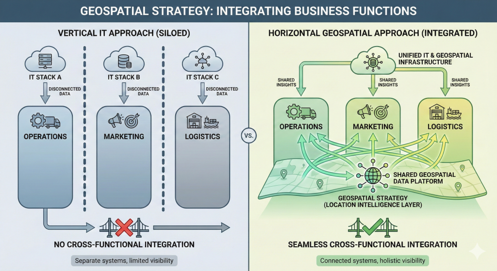
Even if many organizations don’t have a geospatial strategy, they probably have an IT strategy. But the latter is rarely sufficient. Not because it’s poorly done, but because the geospatial function is usually relegated to a single annual budget line item.
IT strategy promotes a vertical, techno-centric view, while doing great things with geo at organizational scale requires a horizontal, capability-centric view. Geo shouldn’t be a footnote to IT strategy, but a primary business focus.
Geospatial Trends 2025-2026: The Future is Now
GeoAI: Artificial Intelligence Becomes Foundational
The integration of AI and machine learning into geospatial workflows is no longer experimental: it’s foundational. Practical applications include automatic detection of land use changes, wildfire risk prediction, deforestation monitoring, and energy network optimization.
Digital Twins: Beyond 3D Models
Digital Twins represent virtual replicas of real environments that update in real-time. Built on GIS foundations, they go beyond simple 3D models, reflecting changes over time. Cities like Zurich, Helsinki, and Boston use Digital Twins for urban planning, asset management, and real-time decisions. The market should reach $25 billion in 2026.

Cloud, Advanced Sensors, and Sustainability
Cloud platforms like ArcGIS Online and Azure Spatial are expanding GIS accessibility with real-time processing. The integration of LiDAR, photogrammetry, and thermal imaging in a single flight increases efficiency and accuracy.
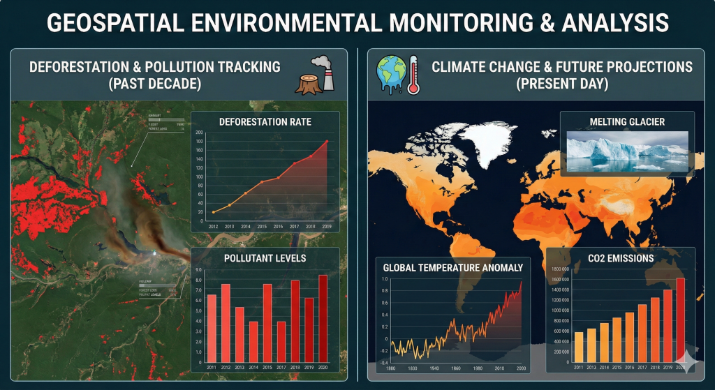
Sustainability is central: regulations like the EU’s CSRD require transparent climate risk analysis. Geospatial analysis supports deforestation tracking, water resource management, emissions monitoring, and climate impact mitigation.
How to Create an Effective Geospatial Strategy
The “Strategy on a Page” Approach
Matthew Lewin and Allen Williams propose an effective framework for condensing geospatial strategy into a one-page document. This approach prevents the strategic plan from ending up “on the shelf” unused, keeping it always present and shared among all stakeholders.
Element 1: Vision
The vision constitutes the organization’s “North Star” and includes three components:
A- Vision Statement:Describes a future where geospatial aspirations have been realized. It should be: focused on future outcomes, clear about the scope of aspirations, aligned with broader business objectives
Example for an energy company: “Our geospatial capabilities will accelerate the efficiency and effectiveness of spatial planning and decision-making across the organization, providing access to secure, high-quality spatial information across our entire asset base, anytime, anywhere.”
B – Supporting Goals: Describe desired outcomes in greater detail. They should be measurable to provide objective success indicators.
C – Guiding Principles: Provide ongoing guidance for strategic decisions. Examples: “Minimize system customization, favor cloud-based deployment “(Technical), “Encourage cross-functional collaboration, provide demonstrable business value” (Business: )
Element 2: Value Proposition
Describes the strategy’s benefits for different organizational stakeholders. Create one value statement for each identified role, speaking to that role’s specific interests.
Example for field inspectors: “Our solutions provide inspectors with real-time access to maps, as-builts, and work orders on any mobile device in the appropriate geographic context.”
Element 3: Strategy
This is the most articulated section, organized around three fundamental pillars of geospatial capability. For each section, organize strategic decisions in order of relative importance, evaluating significance level in terms of goal advancement and organizational impact.
3.1 Technology and Data
Focus on business applications, geospatial data, and IT infrastructure.
Example decision: Migrate internally managed solutions to SaaS. Result: Improved performance, reduced maintenance costs.
3.2 Processes and Governance
Establishes how geospatial technology and services are managed and supported.
Example decision: Create formal geospatial governance structure. Result: Clear accountability, defined decision-making procedures.
3.3 Workforce and Culture
Impacts workforce complement, spatial literacy, and culture of spatial thinking.
Example decision: Develop professional development pathways for key geospatial roles. Result: Align staff skills with evolving technological capabilities.
Element 4: Roadmap
The roadmap describes the sequence of activities to implement the strategy, typically over 3-5 years. Summarize activities into discrete work packages grouped by strategic component, business project, or technical/non-technical type.
Implementation: From Idea to Action
Use Cases and Success Metrics
Once your strategy and roadmap are in place, use cases become the critical bridge between vision and execution. Think of them as the translation layer that converts high-level strategic objectives into tangible, actionable projects that teams can rally around and deliver.
An effective use case tells a complete story. It begins by clearly articulating a specific business problem—not a vague challenge, but a concrete issue that people in your organization face daily. It then identifies who’s affected by this problem, from frontline workers to senior decision-makers, ensuring everyone understands their stake in the solution. Next, it defines what the solution needs to do in functional terms, avoiding technical jargon where possible so that business stakeholders can engage meaningfully. Finally, and perhaps most importantly, it quantifies the expected benefits in terms that matter to the organization: time saved, costs reduced, revenue generated, or risks mitigated.
But creating compelling use cases is only half the battle. Without robust metrics, you’re essentially flying blind, unable to determine whether your geospatial investments are truly paying off or where you need to course-correct. This is where Key Performance Indicators become indispensable. Track how many projects you’re completing against your roadmap to ensure you’re maintaining momentum and meeting commitments. Monitor user adoption rates religiously—the most sophisticated geospatial solution is worthless if people don’t actually use it. Calculate the return on investment for your geospatial initiatives to justify continued funding and expansion. Measure process time reductions to demonstrate operational efficiency gains. And continuously gauge stakeholder satisfaction, because ultimately, if the people you’re serving aren’t happy with the solutions, you need to understand why and adjust accordingly. These metrics don’t just prove value; they guide your strategic evolution and help you make smarter decisions about where to invest next.
Overcoming Major Challenges
Every geospatial strategy implementation faces obstacles, but understanding these challenges in advance allows you to prepare effective countermeasures rather than reacting in crisis mode.
Resistance to change is perhaps the most predictable yet challenging barrier you’ll encounter. People are naturally comfortable with familiar workflows, even inefficient ones, and the introduction of new geospatial tools and processes can feel threatening rather than empowering. The most effective antidote isn’t mandates from above, but rather identifying early adopters within your organization—those curious, forward-thinking individuals who are naturally drawn to innovation. Partner with them to implement quick-win projects that deliver visible, tangible results in weeks rather than months. When their colleagues see real people solving real problems with geospatial technology, adoption becomes contagious rather than forced.
Organizational silos represent another significant hurdle, particularly in larger enterprises where departments have evolved into independent kingdoms with their own data, tools, and priorities. A geospatial strategy inherently requires cross-functional collaboration because spatial data doesn’t respect organizational boundaries—a customer location matters to sales, logistics, customer service, and marketing simultaneously. Breaking down these silos requires more than good intentions; it demands formal governance structures that bring together representatives from IT, GIS, and key business units. This governance body becomes the neutral ground where competing priorities are reconciled, standards are established, and collective decisions are made about data sharing, tool selection, and resource allocation.
The challenge of inconsistent data quality can undermine even the most brilliant geospatial strategy. Garbage in, garbage out remains an immutable law of data analytics, and when your geocoding is inaccurate, your boundaries are outdated, or your attribute data is incomplete, every analysis built on that foundation becomes suspect. Rather than attempting to manually clean data after the fact—a Sisyphean task that never ends—invest upfront in establishing clear data quality standards and implementing automated validation processes. Modern geospatial platforms can flag anomalies, validate against authoritative sources, and even auto-correct certain types of errors, transforming data quality from a perpetual headache into a manageable aspect of your operations.
Budget constraints are a reality for virtually every organization, and geospatial initiatives often struggle to compete for funding against more visible or seemingly urgent priorities. The key is demonstrating early value with limited investment. Prioritize projects that deliver high business impact but require relatively modest resources—perhaps a cloud-based solution that eliminates infrastructure costs, or a pilot project in a single department before rolling out enterprise-wide. Cloud deployment models have fundamentally changed the economics of geospatial technology, eliminating the need for expensive servers, reducing IT overhead, and converting capital expenditures into predictable operational expenses that scale with your needs.
Finally, skills gaps pose a persistent challenge as geospatial technology evolves faster than most training programs can keep pace. You need people who understand both the technology and the business context, a combination that’s increasingly rare. A multi-pronged approach works best: invest in continuous training for existing staff to build institutional knowledge and loyalty; selectively hire specialists who bring deep geospatial expertise; and consider strategic partnerships with experienced consultants or managed service providers who can supplement your team’s capabilities during critical phases or for specialized needs. Remember, building geospatial capability is a journey, not a destination, and your talent strategy must evolve alongside your technology strategy.
Conclusion: The Time to Act is Now
In 2026, geospatial intelligence is no longer an optional competitive advantage: it’s a fundamental business capability. Organizations that treat geospatial data as static resources will fall behind, while those embracing AI, IoT, and real-time analytics will lead the change.
Immediate steps to take:
- Assess current state: Where is your organization on the geospatial journey?
- Define vision: Where do you want to go and why does it matter to your business?
- Engage stakeholders: Identify who will benefit from the geospatial strategy and involve them from the start
- Create strategy on a page: Condense vision, value proposition, strategy, and roadmap into a visual, shareable document
- Start with quick wins: Implement high-impact use cases to generate momentum and demonstrate value
- Measure and iterate: Establish KPIs, monitor progress, and adapt strategy based on results
Geospatial strategy is not a static document to archive, but a living tool that should guide daily decisions, investments, and priorities. Print it, bring it to meetings, share it widely, and use it to keep the organization focused on the common vision.
The future belongs to organizations that understand that “everything happens somewhere” and are equipped to leverage this fundamental truth.
NEXT STEPS
For consultation on creating your geospatial strategy: